
|
Lot: 237 ♡
|
|||||||||||
|
Four-Sheet Copper-Engraved Hand-Colored Map of the United States by A.B. Borghi, 1818-Dated, Choice Near Mint
|
|||||||||||
|
|
|||||||||||
 |
|
||||||||||
|
Lot 237:
Four-Sheet Copper-Engraved Hand-Colored Map of the United States by A.B. Borghi, 1818-Dated, Choice Near Mint
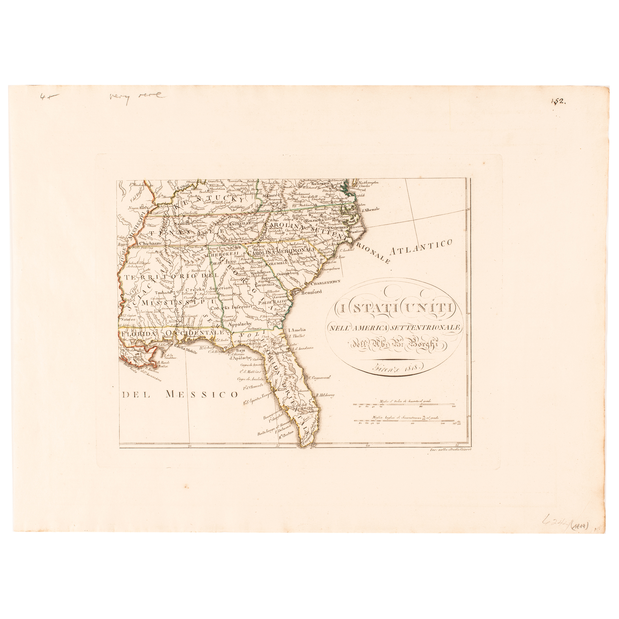
1818-Dated, Four-Sheet Copper-Engraved Hand-Colored Map of the United States titled, “I Stati Uniti Nell' America Settentrionale”, by A.B. Borghi, published in Florence, Italy, Choice Crisp Near Mint. This is the rare complete 4-Sheet format of this Map of the United States with fully wide original untrimmed margins. This rarely encountered Hand-Colored Map titled, "I Stati Uniti nell'America Settentrionale" that was created by the Italian geographer and mathematician Abate Bartolomeo Borghi (A.B. Borghi) published in Florence in 1818. This large-format map is typically formatted on four unjoined sheets with hand-colored outlines delineating political boundaries. This Map shows East and West Florida, an oversized Mississippi Territory including Alabama (mis-located Indiana below Lake Michigan), but with Chicao named and a host of interesting details in the east. The large Inset Map of Nuova Albion and Nuovo Georgia [Oregon Territory] is one of the best large format treatments of the region to date. Texas is named, with wonderful detail along the Arkansas River. Both Lake Timpanagos and Salso lake are named, with an explanation that part of Salsa lake is unknown. The details in the Missouri Valley and throughout the Rocky Mountains and Upper Plains is extraordinary, naming Indian Tribes, lakes, rivers, mountains, settlements etc. This is an exceptionally high quality crisp wide margin, unfolded, example of this rare 4-Sheet Map of the United States with hand-colored in outline. Each copper plate section has outer outlines, showing a strong impression in the paper measures about 10” x 13" plus it has fully wide margins, each individual sheet measures 14.25” x 19". Shown are East and West Florida; an oversized Mississippi Territory; a mis-located Indiana; and much detail in the Louisiana Territory (Luigiana), which extends to the headwaters of the Columbia River. Most notable, is of the presence of the Southwest, featuring a large inset, "Supplemento per il fiume Columbia e Suoi Contorni," with Nuova Albion and Nuovo Georgia [Oregon Territory], including parts of Vancouver Island as well as the Pacific Northwest up from "Baja Bellingham." On the main part of that sheet, Texas is named, and there is a great deal of detail along the Arkansas River. Old reference numbers in upper corners of margins, some recent pencil notations in margins. References: Phillips (Maps) p. 439. A Rare four sheet map of the United Statesby A.B. Borghi, published in Florence. Extending west to the Columbia River and Lake Timpanagos, the map provides are remarkable depiction of the Upper Missouri and Yellowstone River drainages and the region explored by Lewis & Clark, only 4 years after the first publication of the official account and map of the expedition. The large inset map at the bottom left provides an even more detailed treatment of the Columbia River Basin and Puget Sound, again based upon the reports of Lewis & Clark. The map shows east and west Florida, an oversized Mississippi Territory including Alabama, mislocated Indiana below Lake Michigan, but with Chicao named and a host of interesting details in the east. However, it is in the West where the map truly shines. The large inset map of Nuova Albion and Nuovo Georgia [Oregon Territory] is one of the best large format treatments of the region to date and Texas is named, with wonderful detail along the Arkansas River. Both Lake Timpanagos and Salso lake are named, with an explanation that part of Salsa lake is unknown. The details in the Missouri Valley and throughout the Rocky Mountains and Upper Plains is extraordinary, naming Indian Tribes, lakes, rivers, mountains, settlements etc. Overall, a choice quality wide margin example of this rare 4 sheet map of the United States. |
|||||||||||
|
Auction Closing: Saturday, April 18th
at Noon Eastern Time • 9:00 AM Pacific Time |
|||||||||||